
Without being a very person of hiking and walking through nature I am fascinated by the facilities that are in certain countries for all those who enjoy breathing fresh air and contact with the wild. Today’s post goes to these people, because nothing will be open ‘The Great Trail’, the longest path in the world that you can travel all over Canada. From side to side, from top to bottom.
It will be a whopping 24,000 kilometers that will be inaugurated in full by coinciding the date with the celebration of the 150 years of the Canadian confederation. It crosses cities, forests, rivers and roads and offers a multitude of possibilities for those who live or visit the country and theirs is the outdoor activity.

It goes without saying that in all its route is free of motorized traffic (it is not shared we go) and that is perfect to travel in bicycle, on horseback, walking or to stop to do some type of aquatic activity. From everything has seen its size. For how many places? As they cross 15,000 different communities. From big cities to inner zones of forests where you can find when instead a shelter in which to rest, information booths, drinking fountains and even places to rent material to follow your adventure.
You may also like to read another article on NGCATravel: If you go to Canada in 2017 all tickets to the national parks will be free
Behind it is a non-profit organization that has been working for more than 25 years to unite the 400 preexisting trails and turn The Great Trail into a nationwide union. According to them, 80% of Canadians will have a stretch of it less than half an hour from their home and always with easy access from airports and stations.
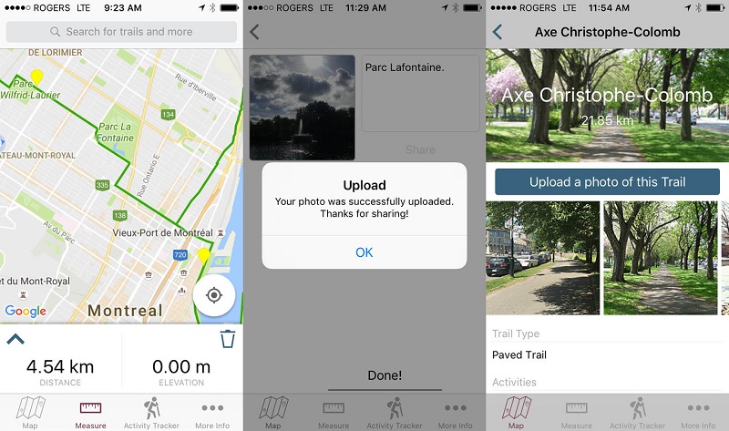
As you cannot miss, they have developed an application to get the most out of every meter of the way, either in Montreal or in the most remote place. Your map helps you to see the road in its entirety and allows you to “autolocalize” with the GPS. Its measurement functionality helps hikers (or cyclists) to plan routes, calculating distances between points. And it also allows you to completely monitor your path, distances and elevations. What can be more paradoxical is that it encourages you to lose yourself in nature and disconnect, but at the same time it encourages you to take your mobile and upload your photos so that everyone can enjoy what you marvel.
Seriously, when I go to Canada of course it will enter into my plans to make a good stretch of this wonder.